Mount St. Helens


June, 2009

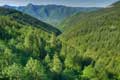
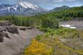
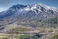
After months of activity, Mount St. Helens erupted on May 18th, 1980, causing immense destruction to the surrounding country. Today, it is a quiet, snow-capped mountain with a large chunk missing from its north side (see photo #1, at left). We visited the Mount St. Helens National Volcanic Monument in late June, on a perfect day with blue skies, pleasant temperatures, and wildflowers in bloom wherever we went. It could not have been more perfect.

After the eruption, the US government put a lot of money into creating a monument where visitors could get a really good understanding of what had happened here. They built a new highway into the area, with all new bridges for easy access. The Johnston Ridge Observatory provides excellent learning opportunities, including a must-see movie that plays every hour or so. You have to see the ending! It is creative and clever, and you won't forget it.

The eruption destroyed huge areas of forest. In some places, the trees were snapped off and knocked to the ground in neat rows. In other areas, closer to the volcano, the trees were ripped loose and carried away, leaving a barren landscape. In some areas, the US Government has left this land as a kind of laboratory to see how nature will renew itself after the destruction. In other areas owned by the Weyerhaeuser Corporation, a great deal of effort was put into reforesting the land (photo #2). The difference is quite dramatic.

In the natural portions of the Monument, the barren soil is being slowly repopulated by small plants, many of them wildflowers. It may take centuries for the forests to return on their own. In the mean time, the land is unprotected by tree roots and is highly susceptible to erosion. The erosion creates beautiful patterns, but the sediments that are carried downstream are a threat to navigation and other uses of the river. A large dam, which we did not visit, has been built to capture and retain these sediments.

One of the most enjoyable parts of our day was to hike the Hummocks Trail down to the edge of the North Fork of the Toutle River (photo #3) The trail is about 2.7 miles long, and goes up and down among the hummocks that were formed by the eruption. It was a fairly arduous trip for Jim, with his bad heart. For a younger and healthier person, it should be an easy hike. In any case, it was a wonderful experience.

We hiked this trail expecting to see the erosive environment of the hummocks, which we saw. We also had many gorgeous views of Mount St. Helens along the trail. However, we were surprised to find ourselves walking through a young forest of cottonwood and other deciduous trees in an often marshy environment. At one point, we walked along a quiet pond that reminded Jim of the beaver ponds he knew as a boy in Michigan. Sure enough, we came across the tell-tale stumps of beaver-felled small trees, and then the beaver's lodge. Beavers are nocturnal, so we didn't see any of them around. It was an unexpected treat to find their dam and pond along our route.

— return to the 2009 Journal Archive.